Featured Post

5 Cults from the 1960s and 1970s

By Nancy Wong - Own work, CC BY-SA 3.0, https://commons.wikimedia.org/w/index.php?curid=44405530 America, and the Western World in ...

Showing posts with label geography. Show all posts

Monday, April 30, 2018

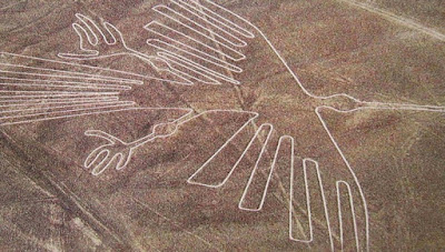
PHOTO: Nazca Lines Hummingbird

Provided by COETAIL.com
Nazca Hummingbird
An aerial image of the Hummingbird Nazca Lines in Peru, courtesy of COETAIL.com.

NOTE:  Shortly after this post was drafted (not published), some piece of blue-collar shit working in, or with, the Intelligence Community (IS) destroyed part of the monument.

The following (infected) link was later discovered in my Bookmarks:
http://www.ancient-origins.net/news-history-archaeology/high-winds-expose-previously-unknown-nazca-geoglyphs-001935( )#!bvGw9W

© The Weirding, 2018

Tuesday, December 12, 2017

The Hollow Earth Theory, or Symmes' Hole

Symmes' Concentric Circles of Hollow Earth
After several posts debating the merits of such theories being connected to Admiral Byrd, I stumbled upon the modern origin of the Hollow Earth Theory or, as it was once called, Symmes' Hole:

John Cleves Symmes, Jr. was a military provisioner and veteran of the War of 1812 who latched onto a popular notion of the era regarding concentric circles and an inner earth.  It appears that these ideas, both in the theoretical and literal, existed prior to Symmes -- Johannes Kepler in 1618, Edmund Halley in 1692, and even Cotton Mather referenced an Inner Earth of concentric circles -- but he somehow came upon the concept independently, perhaps during the War, as Symmes was not a classically educated man likely to have read the likes of Kepler and Halley.

Symmes' Circular Number 1, published on April 10, 1818, begins, "I declare that the earth is hollow and habitable within; containing a number of concentric spheres, one within the other..."  He goes on to give rather precise coordinates to the entrance of this fantastical world before requesting funding for an expedition to validate his claims.  He went on to write many more circulars before taking his theory on the road, speaking to any audience that would have him.

Symmes' Hollow Earth Theory inspired many of his contemporaries, including Edgar Allan Poe and Jules Verne -- both of whom wrote stories regarding a Hollow Earth -- as well as Edgar Rice Burroughs, and others.  In fact, the public became so intrigued that Congress was forced to vote on the matter in 1822.  James McBride, a supporter, published Symmes's Theory of Concentric Spheres in 1826, bringing the Hollow Earth Theory even more mainstream notice.  Though the expedition was turned down -- many times, actually -- John Symmes' Hole Theory deeply impacted popular culture, resulting in countless sci-fi/fantasy classics of both the 19th and 20th -Century.

© The Weirding, 2017

Thursday, June 23, 2016

The Oldest Recorded Sasquatch Sighting (Skræling)

A Viking Foray
A Viking Foray
According to some accounts, the oldest known sighting of a Bigfoot or Sasquatch in "The New World" was recorded by none other than Leif Erikson, or Erik the Red. Erikkson referred to "ugly, hairy men" with great black eyes" who towered over himself and his fellow Norsemen. The name he gave them was "Skræling."

While others insist this description refers to the Thule people, a pre-Inuit peoples who lived in the regions where Ericson and his men are said to have landed, including Canada, some note the inclusion of the word "hairy" as indicative of a different species. The Norse Vikings were, after all, very hairy -- they are most often depicted with great beards and matted hair, themselves.

Perhaps even more intriguing is the connection between the use of the word, Skræling, and the existence of pygmies, possibly throughout the globe. The Vikings were known to grow quite tall themselves, in addition to being hirsute; to many peoples, they would be hairy and towering figures.

As History repeats itself, we are continually finding out that our ancestors knew far more about the world than even we do today, and that many of the "facts" we thought we knew are erroneous.

While the Skræling of which Erik the Red spoke may have been nothing more than the indigenous American peoples of their time, the connection to countless descriptions of Bigfoot seem to cloud the issue.

© The Weirding, 2016

Thursday, June 3, 2010

Pacific Isles Growing, Not Sinking

Not long ago, we brought you a story about a Pacific Island which had finally submerged, and reported that scientists were concerned that global warming was set to sink many more like it. In our defense, we merely regurgitated the facts we read; The OddBlog has no scientists on-hand. Now, many outlets are also retracting that part of the story, as new research from different scientists shows the majority of islands in the area are actually growing, as waters recede, not sinking.

The isles of the Federated States of Micronesia are among those which are growing, thanks to the build-up of coral debris and sediment. The scientists involved predict that these islands will still be there a century from now, though none could say if they will be inhabitable.

The study includes 27 islands and spans 60 years. Most of the islands in the study have remained stable, while others have grown - 80% of them, in fact. Yet, the researchers also said residents should not be lulled into thinking they are completely safe, as global warming is causing area waters to rise, and coastal erosion remains a threat.

© C Harris Lynn, 2010

Thursday, March 25, 2010

Island Disappears in Bay of Bengal

An island whose ownership was disputed by India and Bangladesh has disappeared beneath the waves in the Bay of Bengal. The island - known as New Moore Island to Indians, and South Talpatti Island to Bangladeshis - never hosted a permanent settlement and only rose some 6' above the waters at any time. However, scientists say it is now completely submerged.

They also note that the waters in this area of the world are rising faster in the last decade than they have in the 15 years prior, so it is only a matter of time before other, nearby islands disappear as well!

© C Harris Lynn, 2010

Sunday, June 28, 2009

Mexican Officials Seek "Lost Island"

Mexican officials are desperately searching for Isla Bermeja, a long-lost island which first appeared on 18th-Century maps.  They claim the US is encroaching on Mexican borders, and locating the island would help prove this claim.  Experts believe the sea bottom in the area, to which Mexican officials have already made claim, to be rich with oil.  However, reconnaissance allegedly shows nothing in the area.

Old maps were largely made by copying existing maps, and errors could appear on maps for centuries.  As more explorers made their ways into unchartered territory, and more of the land was explored, these errors were corrected on newer maps.  Isla Bermeja may never have existed, though other popular theories say an earthquake could have removed it, global warming could be to blame -- or the US bombed it!

Experts dismiss this latter claim, but say they will seek more funding to continue searching for the lost island of Isla Bermeja.

© C Harris Lynn, 2009

Tuesday, May 26, 2009

Butt Hole Road is Archer's Way

That's why the cleric likes to go first. What? Sorry.

Residents on Conisbrough, South Yorkshire's Butt Hole Road got sick and tired of all the jokes, all the gags, and the bare bottoms displayed whenever tourists stopped by to take pictures or steal the street sign. So they paid over $500 to change it themselves - to Archer's Way, in reference to a nearby castle.

Apparently, the road was named for a communal water butt which once existed there. But residents were tired of dealing with the whole mess, saying many delivery people and other service providers sometimes simply refused to believe such a road even exists! There is already an online petition circulating to change the name back to Butt Hole Road.

© C Harris Lynn, 2009

Monday, December 22, 2008

Lost World Discovered on Google Maps

Some years back, a team of scientists was looking for a new area to explore at least 5000 feet above sea level.  They were astonished when they discovered a patch of forest in Africa not on any map.  How?  Google Earth, of course!

The forest surrounding Mt. Mabu had been overlooked for years by wildlife experts and cartographers alike, largely due to decades-long war in the region.  While few Mozambiqueans are even aware of the 27 acres of lush forest growth (or Mount Mabu), those who are have kept it secret as they use it for refuge when the fighting becomes too intense.  Researchers note that, while it may be on some maps under another name, Mt. Mabu is basically unknown.

Once discovered, a team of researchers from several countries (including Mozambique, Switzerland, Britain, and more) made the trip to discover a lush Eden, filled with rare and exotic species of butterflies (including three new species), giant snakes (including a new adder), and colonies of rare birds.  They returned home with some 300 samples of flora, and more discoveries have yet to be made.

The Mail Online has more on the trip, including pictures.

© C Harris Lynn, 2008

Saturday, May 24, 2008

Vast Cracks Found in Arctic

Canadian research teams unveiled evidence of giant cracks in the Arctic Shelf yesterday.

This is being hailed as dramatic evidence of the ice caps breaking apart. The cracks were part of a 10-mile network on Ward Hunt, the area's largest shelf. It indicates the individual pieces could float away at any time.

Last year, we brought you news about the Ayles Ice Island, which has since split into two pieces. These developments are part of an "emerging pattern" in the Arctic, which recent data suggests may have more to do with natural, biological factors than anything man-made.

© C Harris Lynn, 2008

Sunday, May 18, 2008

The Oceanic Dead Zone

An oceanic "dead zone" has been discovered off the coast of Oregon. Scientists say the lack of Oxygen in the area can kill any creature caught in the area that cannot swim/scuttle away fast enough!

There are hundreds of these dead zones worldwide, mostly caused by pollution, but this one (which exists between the states of Oregon and Washington) was caused by winds and currents which disrupted the ecosystem. You can take a tour of the area through the video on this page from the Smithsonian website. It is about halfway down, on the right.

Many things can cause dead zones and many will disappear and recur over the span of several years. Most are small areas, but some span miles.

© C Harris Lynn, 2008

Tuesday, April 15, 2008

Pollution Leads to Pneumonia?

A new study found that areas with higher levels of pollution also tend to have higher rates of death from such illnesses and diseases as pneumonia, cancer, and COPD.

While the author warns that more research is necessary, he believes the study clearly shows "a strong correlation" between air pollution and respiratory illness.  Social factors, such as smoking and deprivation, also contribute, and the researchers could make no division between car pollution and other chemical components.

Areas with the most deaths had higher levels of pollution, generally related to auto exhaust.  Pneumonia tended to be the major cause of death in these areas.

© C Harris Lynn, 2008

Tuesday, June 26, 2007

Nexus Points (Ley Lines)

Nexus points are most often discussed in conjunction with Ley Lines.  Ley Lines are said to be invisible lines across the surface of the Earth which possess or enhance magical or paranormal properties at their intersecting points.  For this reason, landmarks have often been positioned along these lines.  While much has been made of ley lines in certain circles, nothing conclusive has come to light.

While there are some interesting coincidences as to how certain landmarks and features seem to line-up (particularly in Europe), my personal theory is that this was a practical matter for ancient peoples who used these landmarks as exactly that: Travel guides, later (and once upon a time) connected by roads.  Of course, these ancient architects may very well have felt that there were some mystical properties to these features and/or the way they lined-up, but we may never know.

I generally tend to discount anything having to do with Ley Lines.

On quite the other hand, I believe there is some kind of evidence for "nexus points" -- places, locations, and areas which, for whatever reason, lay at the center of, or form a bridge between, our corporeal world (the Prime Material Plane, in many cases) and The Other Side (Spirit World, Dead World, even sometimes the Astral Plane -- though this latter term is incorrectly used).  In particular, there are places, such as the Borley Rectory, which do not seem to fit into any preconceived notions of your typical haunted house.

We've all heard the concepts of how, if a house is built on consecrated, holy, or "haunted" land, the structure itself will play host to the spirits there.  True to form, when the Borley Rectory was destroyed, the remains of a young woman were reportedly found buried beneath the basement.

But there is a question as to "Veridical Imagery," or "Afterimage" -- a term with which even experienced investigators might not be aware, though they all know the concept: Great distress, pain, or emotional hardship can leave what is basically an emotional photograph on an area that becomes visible or active (as emotional motion pictures) at times and/or to different people (often called "Sensitives," "psychics," or "mediums").

Thursday, May 24, 2007

Smoky Haze

When I woke up this morning, it looked overcast.   I couldn't tell if it was humidity or heat, but I didn't want to be out in the middle of it.  Needless to say, by a little after noon, I had to be.

The first thing I noticed when I left the house was the smell: Something was burning, but I couldn't tell what.  It smelled like paper burning or maybe garbage.  I was afraid because I live in an apartment complex, but I knew that there would at least be smoke alarms going off, if not any firetrucks in the parking lot.  I looked and looked, but it was obvious from the kids running around and people coming and going that nothing was going on around where I live, so I left.

The haze was everywhere.   I had to drive about 3-4 miles down the road to the store and the haze was all across the roads.  When I got to the store, the smoke was as far up and down the highway as I could see.  Making my purchase, I looked down at the newsstand and noticed on the front page of the local paper where an old gymnasium had burned to the ground.  I didn't look at the story too hard, but I immediately asked, "Is that where all this smoke came from?"

The woman's eyes lit up and she said, "No! They said on the Nashville radio station that it was being blown up this way from the wildfires in Georgia!"

I was a little stunned.  Georgia is at least 2-3 hours from here at the closest and I had no idea the fires were nearby!  The reports I'd heard had said they were between Florida and Georgia, which I assumed meant they were on the far side of the latter state, and that's quite a ways from here!

I guess I just didn't realize how great the fires were nor how far smoke could travel.   It really wakes you up to the whole global warming issue and puts a lot of other things into perspective, as well.

Everyone's so concerned with how technology and the Web have "made the world a smaller place," but something like this really reminds you that the world isn't an infinite landscape.  Of course, intellectually, we all know this, but emotionally, I think it's easy to forget just how small the world really is.  When you look at a map and see all the distant lands, all the countries you've never even heard of, all the places you'll never visit, everything seems so far away.

By late afternoon, the haze had cleared away and it no longer smelled of smoke, but the whole thing really set my little gerbil wheel in motion.
Tuesday, May 22, 2007

Scientists Land on Ice Island

Scientists, along with a BBC team, have landed on the Ayles Ice Island, a chunk of the Ayles Ice Shelf which broke away in 2005 and was only recently identified.  They went there to "tag" it with a monitor -- not unlike how wild animals are tagged -- so scientists can follow the Ice Island's movements in the Arctic.

It now floats about 400 miles from the North Pole in one of the fastest-warming regions of the Earth.  It broke from the Ayles Ice Shelf in less than an hour back in August 2005, registering with the force of a small earthquake.

Records show this region of the Arctic has lost as much as 90% of its ice in the last century.  The map of the Arctic will have to be redrawn.